Brockley Foxes Wild in the City
John is a PHD student at University College London, studying the impact of hyperlocal communities like this one.
As part of his research, he'll be asking BC readers to be interviewed, but for the time being, he has another request - one which we're hoping as many of you as possible will be willing to help with.
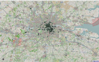
Below is a series of maps of Tweets by Brockley Central's followers during the course of one week in May this year, selected at random. He's taken the geolocated tweets and mapped them to see where BCers travel, a bit like Channel 4's fox-tracking experiment earlier this year. A couple of things to point out here:
Second, there are plenty of people who follow BC, who are not regular BC readers - some are journalists, some are colleagues or friends, some are randoms, who follow BC out of idle curiosity.
Therefore, this is by no means a reliable guide to how BCers move around the city (and the world). However, the weight of the Tweets is interesting and suggests a few patterns.
First, most BCers seem to work in London Bridge and the West End, rather than East London and Canary Wharf. Despite the rise of the East London Line, we're mostly commuting north-west, rather than north or east.
Second, you can see lines of tweets tracing the route of the train lines to London Bridge and Victoria. Lots of the tweeting gets done during the the morning and evening journeys - possibly motivated by transport frustrations...
Third, and for us the most striking thing, is how little activity there is south or east of the BC catchment area. Very few of us seem to journey outwards - our time and attention is focused on London's inner core.
This mapping exercise was just a warm-up for John. He'd like to run it again, with as much geolocated data as possible. So please would BCers enable geolocation on Twitter for the next week, so he can build as accurate a picture as possible. The data will be anonymised in his write-up, with usernames and content stripped before they are plotted.


